THE GRUNDEL AND SIMPSON PLANS
The Norman B. Leventhal Map Center Collection at the Boston Public Library includes an 1887 plan for Sorrento Maine by landscape architect Hermann Grundel. The plan was a gift to the library in 1912 from the estate of Henry W. Haynes, a Boston lawyer and trustee of both the library and the Massachusetts Historical Society. I have been unable to find any ties Haynes may have had to Sorrento.

Shortly after acquiring their first parcels of land on Waukeag Neck, the partners of the Frenchman's Bay and Mount Desert Land and Water Company engaged Grundel to design their new resort of Sorrento. The plan shows not only street layouts in the new development but includes an illustration of the company's other property, the Waukeag House in Sullivan Harbor.

There is very little known about Hermann Grundel, other than he is referred to as a landscape architect. Contemporary accounts also refer to him as a "florist." An 1890 edition of the Massachusetts Horticulture Society journal relates a story from a Mrs. H.L.T. Wolcott who said that Grundel had recommended to her the best method to cultivate roses.


The city received twenty-three entries for the new Back Bay Fens, and the commissioners selected Hermann Grundel's plan for the park. Although they awarded him the $500 prize, the city later rejected his design.

The commissioners likely declined to use Grundel's plan because of the objections made by another designer, Frederick Law Olmsted. Olmsted appealed to the head of the commission arguing that Grundel's design completely ignored the realities of the site.


The park commissioners report diplomatically explained that the Olmsted plan was substituted for Grundel's winning submission and construction on the park began after 1880.


Olmsted's plan dealt with the brackish marshland by flushing it with fresh water daily. It included a string of public gardens and turned what had been a public health nuisance into an attractive green space. New train lines terminated at the park and real estate values in the area soared. Of course, the Boston Red Sox later made the area even more desirable when the team constructed Fenway Park nearby in 1912.

Charles H. Lewis may have learned about Grundel's abilities after he won the Fens Park competition. Lewis needed a design for his new resort in Maine and hired Grundel to draw up a plan. Grundel did not disappoint. When Lewis hired him in 1886 or 1887, the land company owned only a small portion of land on Waukeag Neck. Despite this, Grundel's plan for Sorrento included street grids and avenues laid out for large areas of the lower half of the peninsula not owned by the company.

A portion of the Bean Point section designed by Grundel is framed in the Sorrento Library. When the first few lots in Sorrento were sold by the land company, these deeds reference locations on "The Grundel Plan."

Grundel's plan shows his ideas for creating sweeping non-linear avenues. His design concept for several streets radiating like spokes from the top of the hill -- above where the pool is today -- and down to the back bay, are particularly striking. Perhaps like the Boston commissioners, Grundel's plan was found to be impractical, especially since he seems to have created a plan for pieces of land that Lewis had not yet purchased.

Regardless of the reason, Grundel was not hired to do the survey and final street grid layout. This work was done by a local surveyor named Gilbert E Simpson. Later sections of the development, including Doane’s Pt., are better quality surveys and are referenced on deeds as “The Simpson Plan.” While the first Simpson Plan and the Grundel Plan for Bean Point are similar, Simpson's was the one used for most real estate transfers and is more detailed, although perhaps less artistic.

There was another local surveyor named Simpson also involved in the area's land developments – Charles P. Simpson. Charles P. Simpson’s name was on the 1883 survey of Hancock Point. He was also one of the founders of the Long Pond Water Co. which was organized in 1885, prior to the development of Sorrento.
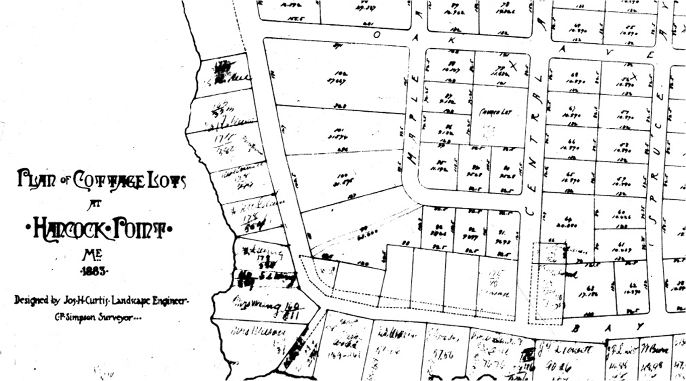
Charles Simpson’s wife was a descendant of Daniel Sullivan, and the Simpson family was long established in the Town of Sullivan. Charles P. Simpson would go on to do other work in the area, first as the engineer for the land company in Winter Harbor and then he and his son Paul worked with the Rockefellers constructing the carriage roads on Mount Desert Island.

I believe Gilbert E. Simpson was Charles' uncle or cousin. Because Charles is listed on some early deeds as the secretary of the Frenchman's Bay land company, it is possible that Charles recommended Gilbert to do the initial Bean Pt. survey of Sorrento. By the Summer of 1888, Gilbert completed additional grid plans for several other sections of the Sorrento resort, including Doane’s Point. These better quality "Simpson Plan" surveys include street names and lot dimensions (see Hancock County deeds, Book 1, pages 44, 45, 46 & 47).


No comments:
Post a Comment